
Mapping Soil PH and Phosphorous

Grid soil sampling allows fertiliser and soil ameliorants to be applied in a more targeted manner, which has the potential to prevent over-liming and reduce costs.
Precision Agriculture is a business that provides soil sampling and data management. One of the services offered by Precision Agriculture is soil sampling on a two hectare grid pattern, followed by the production of pH and Phosphorous maps, plus application maps detailing the amount of lime or fertiliser required on each zone within the paddock.
pH maps are used to apply lime more efficiently, while Phosphorous maps can be used to create variable rate fertiliser maps for sowing, or to reduce variation in paddocks by spreading manure or single super.
In addition to sampling and interrogating data, Precision Agriculture will work with growers or contractors to set up and operate machinery, enabling them to apply fertiliser or soil ameliorants on a variable rate basis.
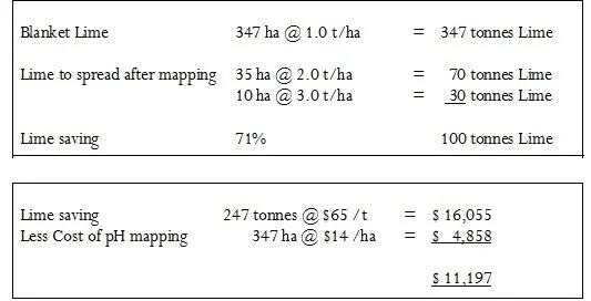
An example from a client who recently pH mapped a group of paddocks to be limed, demonstrates the potential benefit of the process.
In this example, an area of 347ha was mapped for pH prior to sowing canola. Before pH mapping, a blanket rate of 1.0 t/ha was devised from soil tests taken across the previous paddock boundaries. The map shows highly acidic soil in red, moderately acidic soil in yellow and slightly acidic soil in blue.
Calculated lime savings are provided below:

Key: Red - highly acidic Yellow – moderately acidic Blue – slightly acidic
This process is likely to be of value to clients who have:
Variable soil types
Larger blocks comprising a number of smaller paddocks with varying liming histories, having had the fencing removed
A history of liming and are at risk of over-liming lighter soil areas within a paddock or block
More information on soil nutrient mapping can be found at www.precisionagriculture.com.au/variable-rate